The Library holds millions of items- books, journals, e-books, maps, music, moving images- and these can help individuals build both practical and emotional resilience in the face of the climate crisis. Be it a map showing the effects of coastal erosion in Scotland or an e-book on climate justice or a poem deepening our relationship with nature, the collections we hold can inspire people to take action in their own communities.
This blog is part of a short series highlighting how collection items can be used to tell the changing environmental stories of sites across Scotland. The examples are drawn from across our Collections.
More than a third of the population of Scotland live within the River Clyde catchment area. The area most at risk to sea level rise is within the area defined by SEPA as ‘Glasgow Coastal’ which runs along the river from the heart of the city of Glasgow to the Firth of Clyde but also incorporates the tributaries of the rivers White Cart and Black Cart and so includes the areas around Paisley and Renfrew. It includes businesses as diverse as Glasgow Airport and Braehead shopping centre.
COASTAL IMPACT
Climate Central | Land projected to be below annual flood level in 2050

A new and exact map of the River Clyde done by the late Mr. John Adair / now publish’d for the good of the publick by Geo. Scott, 1731.
Sustainable, coordinated management of the Clyde Marine Region by Clyde Marine Planning Partnership, 2017, as saved in the Web Archive.
Comparative sections of Clyde, opposite Estates of Erskine 1835 and 1880, from the Stevenson Collection [Library reference MS.5846/ 72]
Diagram shewing the rise & fall of the River Clyde at Hutcheson Bridge during the Flood on the 8th, 9th, 10th & 11th of Feb. 1831. From the Stevenson Collection [Library reference MS.5851/71]
Nieuwe Caart van de Rivier van Glasgow in ‘t Groot by Johannes van Keulen, 1780.
TRANSPORT
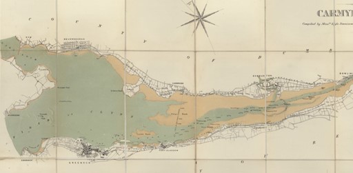
Clyde navigation : Map of the river and firth of Clyde from Carmyle to Gourock / compiled by Messrs. Kyle, Dennison and Frew … from Ordnance and actual surveys, 4th Aug. 1883.
Glasgow Airport, film by the Scottish Educational Film Association, 1969. Documentary on Glasgow Airport showing flight movements, radar, passenger flow, and emergency services at work.Glasgow Airport is within the area at risk from sea level rise, storm surge and flooding.
Climate Change Adaptation Progress Report for Glasgow Airport. 2016. Available to read in the Library; UK legislation regulates access to this resource, available on Library computers in our reading rooms and public access centre.
Glasgow Airport Rail Link Bill. SPICe Briefing ; 06/17, by Alan Rehfisch and Alasdair Reid for the Scottish Parliament, 2006.
Transport and power, 1966. Film taken for a schools programme on transport which includes the newly opened Abbotsinch airport, the BEA air hospital plane, ship building and road construction.
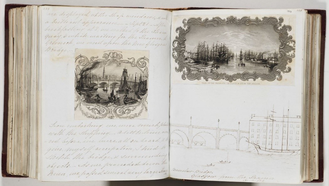
Page from a journal of a tour of Scotland kept by Miss Sarah Taylor of Birmingham, describing a visit to Glasgow, with engravings of Broomielaw Bridge and Glasgow Harbour and sketch made while waiting for the steamer to Greenock, 1842. [Library reference MS.8927, ff.139v-140r]
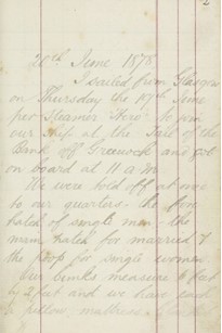
Page from a journal kept by Alexander Kennedy, emigrant from Greenock to Australia, 1878. describing his departure upon the steamer ‘Hero’. [Library reference Acc.10673, f.2r]
LAND-USE
Recovering the Clyde. Scottish Environment LINK, 2014. Available to view onsite at the Library.
Map of the basin of the Clyde including Renfrewshire with the greater part of Lanarkshire and Ayrshire … from a survey by James Knox … (Engraved by Jn. Muir [and] W.H. Lizars), 1837.
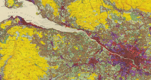
Land Utilisation Survey, Sheet 72, Glasgow, 1940. The key clearly shows the wide variety of land use in the area from industry through nurseries to rich farmland and woodland.
INDUSTRY
Industrial Clydeside ,1938.This film shows the industrial development of Clydesdale, including its iron and steelworks, textile mills and shipbuilding
The River Clyde. 1954. The river from source to sea; farming and fruit growing in the Lanarkshire countryside and the river’s traditions of heavy industry and shipbuilding.
A History of the County of Renfrew from the Earliest times by W.M.A. Metcalfe, 1905.Includes a short chapter on the industries of the area including dying, printing and engineering.
Town Plan of Greenock, Ordnance Survey, surveyed 1857 at a scale: 1:500 in 20 map sheets. The large scale plans show the docks and manufactories around the shore associated with the shipbuilding industry, including dry docks, chain cable shops, and forges.
ENERGY
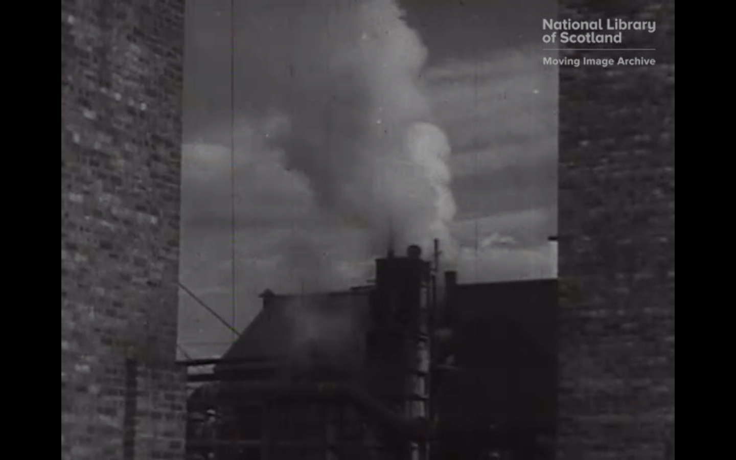
Dalmarnock, filmed by Matthew W.H. Murdoch, circa 1950. Footage of Dalmarnock power station in Glasgow.
Developing Scotland’s Energy Infrastructure, a Guide to Energy Masterplanning. Scottish Enterprise, 2015.
BUILDINGS
Glasgow Docks, 1973. General film views of Glasgow docks.
Plan of the castle at Dunbarton circa 1760?
Plan of part of the North-end of Dunbarton Castle; with two different Designs, and proposed situation for a Barrack to accommodate a Company of Foot; also a Project for rebuilding the Wall near the One Gun Battery by Henry Rudyard, [1788].