Collated by Veronica Bell.
East Dunbartonshire was formed in 1996, from the former Bearsden and Milngavie district, and most of the former Strathkelvin district. Situated to the north of Glasgow, it contains many of the city’s suburbs and commuter towns. Its county town of Kirkintilloch has a rich industrial heritage, partly due to its rail links and position on the Forth and Clyde Canal. Coal mining was an important industry for the county, with many sites across the area from Baljaffray to Twechar. East Dunbartonshire is also is home to significant archaeological sites of the Antonine Wall which runs through the county.
As a recently created local authority the archival record for East Dunbartonshire is scattered across the historic counties of Dumbartonshire, Stirlingshire and Lanarkshire.
Where to find local collections:
Archives & Local Studies, William Patrick Library, Kirkintilloch https://www.edlc.co.uk/heritage-arts/local-history https://www.edlc.co.uk/heritage-arts/archives
Books – non fiction:
Court book of the Burgh of Kirkintilloch 1658-1694 [In Scottish History Society Publications] https://digital.nls.uk/125885888
Bearsden Academy, East Dunbartonshire Council. Education Scotland, 2016. https://search.nls.uk/permalink/f/sidtjd/44NLS_ALMA51639897180004341
Film:
Kirkintilloch Lion Foundry, 1984.
https://movingimage-onsite.nls.uk/film/7136
War Weapons Week 1942 by Ewen Jeen, 1942. (Demonstrations of various civil defence and military units during World War 2 in Bearsden). https://movingimage.nls.uk/film/3348
Fickle Fortune by the Bearsden Film Club, c.1930. https://movingimage-onsite.nls.uk/film/0509
George Bennie railplane system of transport, 1929-30. Built at Milngavie. https://movingimage-onsite.nls.uk/film/1341
Manuscript Collection:
Typescripts, with a few manuscript annotations, of satirical verses about events in Milngavie by Robert Mclellan. https://manuscripts.nls.uk/repositories/2/archival_objects/49625
Maps:
Map of Dumbarton Shire from actual survey by John Wood, engraved by T. Clerk, 1818. https://maps.nls.uk/view/216442554
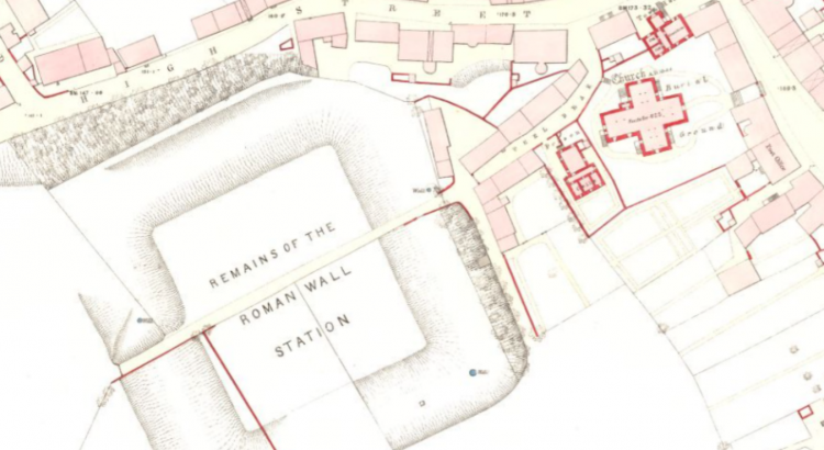
Town Plan of Kirkintilloch, 1859. [In Ordnance Survey large scale Scottish town plans, 1847-1895] https://maps.nls.uk/townplans/kirkintilloch.html
A plan of the Great Canal from Forth to Clyde, 1785. By R. Whitworth, J. Laurie, J.Ainslie. [In Canal plans of Scotland, 18th-20th centuries] https://maps.nls.uk/view/216547704
An e-resource:
Early Bronze Age Pits at Inchbelle Farm, Kirkintilloch, East Dunbartonshire, by P. Masser and A. McSween. [Through JSTOR, access via NLS login] https://www.jstor.org/stable/27917472
A business:
Wester Auchengeich coal mine near Lenzie. Scottish Coalmining. SEFA, 1953. [In Moving Image Archive] https://movingimage.nls.uk/film/0496
A person:
Jessie King, artist born in Bearsden and one of the ‘Glasgow Girls’. Read her entry on pg 235 in The new biographical dictionary of Scottish women by E. Ewan, R. Pipes, J. Rendall and S. Reynolds, 2018. [In Ebook Titles] https://search.nls.uk/permalink/f/hha760/44NLS_ALMA51637119380004341
A poem:
‘An Elegy’ (1798/9) for Reverend Mr. William Dun, late Minister of Kirkintilloch. [Broadside in The Word on the Street] https://digital.nls.uk/broadsides/view/?id=16021
An historic building:
St Mary’s Church in Kirkintilloch is over a hundred years old. View the Laying of New Foundation Stone at Kirkintilloch Parish Church, 1913 : https://movingimage-onsite.nls.uk/film/1374
View footage of events in 1961 here, in St Mary’s: https://movingimage-onsite.nls.uk/film/9554
A Drawing:
Antiquities discovered at the station of Achindavy on Grime’s Dyke…by William Roy, 1793. [In Roy Military Antiquities of the Romans in North Britain, 1793] https://maps.nls.uk/view/74486040
Something about the county town:
Kirkintilloch is twinned with Yoichi in Japan, due to the connection with Rita Cowan Taketsuru who was born in the Scottish town. Yoichi even has a Rita Road. [In NewsBank Access U.K. & Scotland Newspapers, access via NLS Login] https://infoweb-newsbank-com.nls.idm.oclc.org/apps/news/document-view?p=UKNB&t=&sort=YMD_date%3AD&maxresults=20&f=advanced&val-base-0=taketsuru&fld-base-0=alltext&docref=news/176F9B22DEA88A90
Something about a village or small place:
Description of Lennoxtown and surrounding area in 1837 [In Scottish Post Office Directories] https://digital.nls.uk/directories/browse/archive/85593820
Further reading:
Around Milngavie, Mugdock, Balmore, Baldernock and Bardowie, by James Crawford. 2016. https://search.nls.uk/permalink/f/sbbkgr/44NLS_ALMA21471977350004341
Thomas Muir of Huntershill: essays for the twenty first century, eds. Gerard Carruthers and Don Martin. 2016. https://search.nls.uk/permalink/f/sbbkgr/44NLS_ALMA21501417670004341
Bearsden: A Roman Fort on the Antonine Wall, by David J. Breeze, 2016. https://search.nls.uk/permalink/f/sidtjd/44NLS_ALMA21456160960004341